Castlefield: Manchester's Free Canal Quarter
Castlefield is where Manchester keeps its oldest and newest history side by side: a Roman fort, the country's first industrial canal and a green viaduct in the sky, all free to walk.
Short answer
Castlefield is free to explore at all times: an open urban heritage park containing the reconstructed Roman fort of Mamucium, the Bridgewater and Rochdale canal basins and the National Trust's Castlefield Viaduct, none of which charges for entry.
Castlefield is Manchester's oldest quarter and its most generous one for a free day out. It is an open urban heritage park containing the reconstructed Roman fort of Mamucium, the canal basins where the Bridgewater Canal met the Rochdale Canal, several layers of Victorian railway viaduct, and the National Trust's garden-topped Castlefield Viaduct. Every one of those is free to enter or walk through, at any time, because it is public space first and attraction second.
Few visitors realise that this quiet pocket south west of the city centre was, in sequence, a Roman garrison, the birthplace of the industrial canal age and the site of the world's first passenger railway terminus. Liverpool Road station, which closed to passengers in 1844 and now forms part of the Science and Industry Museum, stands at the edge of the basin. The Romans called the fort Mamucium, the "breast-shaped hill", and that name is the root of the word Manchester itself.
The quarter's main asset for a visitor on a budget is simply that it is public realm. The towpaths, the cobbles, the basins and the viaduct arches are all maintained as open space. Nothing here sells you a ticket to walk through it.
What Is Castlefield And Why Does It Matter?
Castlefield was designated the UK's first Urban Heritage Park in 1982, an early attempt to protect an industrial landscape rather than a palace or a castle. The designation covers the Roman fort remains, the canal basins, the warehousing on Duke Street and the railway viaducts that cross the whole area on brick arches.
The quick facts:
| Layer of history | What survives today | Cost to see it |
|---|---|---|
| Roman (founded c. 79 AD) | Reconstructed fort wall and gateway, some exposed foundations of Mamucium | Free, open public space |
| Canal age (1761 onwards) | Bridgewater Canal basin, Rochdale Canal junction, warehouses, locks | Free public towpaths |
| Railway age (1830 onwards) | Viaducts crossing the basin, Liverpool Road station buildings | Free to view from below; Castlefield Viaduct walkway free, Wed to Sun |
| Modern regeneration | Restored basins, bars in arches, footbridges, heritage trail markers | Free |
The name is slightly confusing: Castlefield names the whole district, and it also gives its name loosely to the canal basin area at its heart. Everything discussed in this guide sits within a ten minute walk of Deansgate, the long shopping street that forms the quarter's north eastern edge.
Where Is Castlefield And How Do You Get There?
Castlefield sits immediately south west of Manchester city centre, bounded roughly by Deansgate to the north east, the River Medlock to the south and the Rochdale Canal to the east. Deansgate and Deansgate-Castlefield Metrolink stops both serve it; the tram stop with the longer name is the closer of the two to the basin itself.
The walk from Manchester Central Library on St Peter's Square takes about fifteen minutes down Deansgate, and passes the John Rylands Research Institute and Library on the way, which is free to enter with no booking required. Oxford Road and Deansgate railway stations are both within reach for anyone arriving by train.
Because the whole quarter is public space, there is no entrance, no opening time for the streets themselves and no closing time. The pubs and bars in the arches keep their own hours, but the towpaths and the fort area are walkable at any hour, and well lit along the main routes.
Those four walks are all free, pay-what-you-want tours run by independent local guides on GuruWalk, and they are the featured English-language walks this site covers. The Radical History Tour, rated 5 out of 5 across 23 GuruWalk reviews, is the one with the direct Castlefield connection: it meets on Duke Street, at the heart of the heritage park, and its official listing is "Radical Manchester - How Manchester Changed the World". The meeting point is no accident, as Castlefield's industrial past is precisely where Manchester's radical history begins.
What Can You See In Castlefield For Free?
The short answer is most of the quarter. The one attraction here with any kind of entry process at all is the Castlefield Viaduct, and even that is free. Here is the honest map of what costs nothing:
| Castlefield sight | Free status | Anything to know |
|---|---|---|
| Mamucium Roman fort remains | Free, always | Open public space; reconstructed gateway and wall section |
| Canal basins and locks | Free, always | Public quaysides and towpaths around the water |
| Railway viaducts (exterior) | Free, always | Best viewed from the basin and the Duke Street bridge |
| Castlefield Viaduct walkway | Free, Wed to Sun, 10am to 5pm | National Trust run, walk-up entry in its current phase |
| Liverpool Road station exterior | Free to view | The station buildings are part of the Science and Industry Museum site |
| Science and Industry Museum | General admission free | A free timed ticket must be booked online in advance; paid extras exist |
A note on that last row, because it is the quarter's one genuine conditionally free site. The Science and Industry Museum's general admission is free, but the museum asks visitors to book a free timed ticket online in advance to manage capacity, and its special exhibitions and the Power Up interactive experience are paid separately. It would be dishonest to call the museum "simply free" without that sentence, so it stays attached.
Mamucium: The Roman Fort Under The Viaducts
The fort of Mamucium was established around 79 AD, when Roman troops pushed north and built a garrison on a sandstone bluff above the Medlock. What stands today is partly reconstruction: a rebuilt section of the fort wall and a timber-framed north gate, raised in the 1980s on the line of the Roman foundations, which remain visible as low courses of stone below the modern walkway.
The position is striking now for the opposite reason it was striking then. The Romans chose the bluff for defence. Today the same spot sits directly beneath the arches of a nineteenth century railway viaduct, so a visitor standing at the fort wall can look up through two thousand years of the city's built history in a single glance: Roman stone, industrial brick, Victorian iron, and beyond it the glass of the modern skyline.
The fort area costs nothing to visit and has no posted hours, because it is simply part of the public realm. Information boards around the site explain what the reconstruction shows and what lies underneath. The site also connects to the wider story of the city's name: Mamucium, softened and shortened through Old English, is where Manchester comes from.
This is the fort after which the walks meet. Several of the free GuruWalk tours of central Manchester route through this part of Castlefield precisely because the radical history of the city, from the industrial revolution through Peterloo to the suffragettes and the modern city, is easiest to tell standing where the industrial revolution's transport network physically began.
The Viaducts: A Skyline Built Of Arches
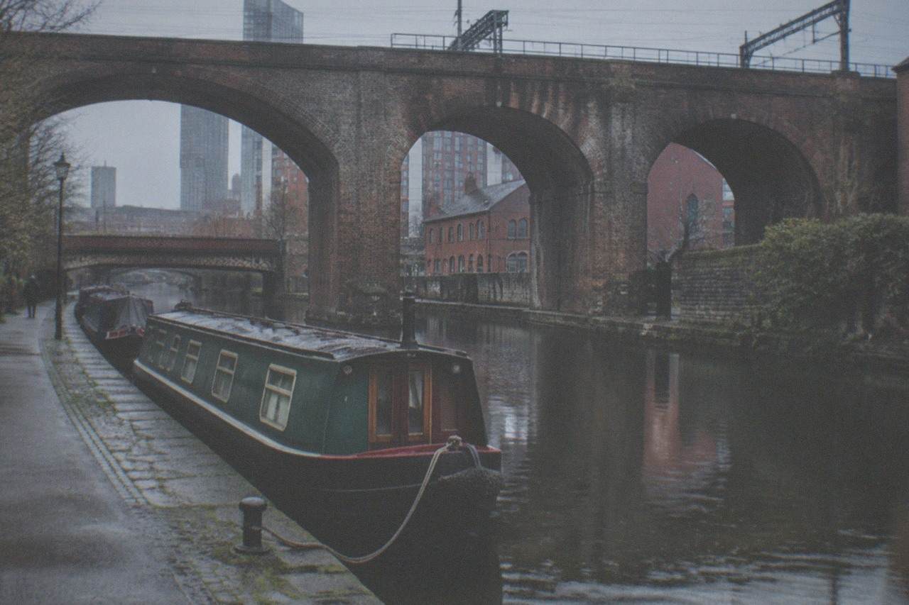
Castlefield's most photographed views are the ones looking up. From the middle of the canal basin, the eye meets a dense stack of viaduct arches carrying railway lines toward Deansgate station, Oxford Road station and beyond. These structures date mostly from the second half of the nineteenth century, built in red brick with stone detailing, and their arches now house bars, restaurants and event spaces while the trains still run overhead.
The best free viewpoints for the arches are the quay walls around the main basin, the Duke Street bridge over the Rochdale Canal, and the approach from Liverpool Road. Photographers tend to favour the late afternoon, when the low sun comes down the line of the basin and the brickwork glows.
Directly above the north end of the quarter sits the Castlefield Viaduct itself, a steel truss structure from 1892 that carried rail freight until the 1960s and stood derelict for decades afterwards. The National Trust took it on and reopened its deck in 2022 as a sky park, planted with gardens and open Wednesday to Sunday, 10am to 5pm. Entry is free, walk-up in its current phase, which means no advance booking is required, though that arrangement has changed before and is worth rechecking before a visit. The viaduct deck is the single best free view over the canal basins in the quarter, because you look down on the very arches everyone else photographs from below.
The Bridgewater Canal: The Canal That Started Everything
The Bridgewater Canal is the reason Castlefield exists as a heritage site rather than a footnote. Opened in 1761 to carry coal from the Duke of Bridgewater's mines at Worsley into the heart of Manchester, it is usually described as the first canal in Britain built with no natural river along its route, and its commercial success detonated the canal mania that followed. The basin at Castlefield, where the canal's terminal branches once spread among warehouses, is the oldest surviving part of that network in the city.
The Castlefield stretch of the Bridgewater is the calm water at the heart of the quarter, the part where narrowboats moor against the quay and the viaduct arches double in the surface. The towpath is free public space, maintained by the Canal and River Trust, and it runs west from the basin toward Pomona and eventually the water parks of Trafford.
Walking the towpath costs nothing at any hour. The route west out of the basin is one of the quietest half hours in central Manchester, threading between the water and the railway embankment, and it connects, for anyone with the legs for it, toward the Bridgewater's later reaches and the Traford suburbs. For most visitors the stretch that matters is the first few hundred metres: basin to first lock, with the arches overhead all the way.
The Rochdale Canal: Locks, Bridges And The Towpath East
The Rochdale Canal arrived forty years after the Bridgewater, opening fully in 1804 as a broad canal crossing the Pennines to Yorkshire, and its junction with Castlefield's network gave Manchester its first through water route to the east coast. In the city centre the Rochdale runs through what is now one of the most varied stretches of urban towpath anywhere in England: from the Castlefield basin it climbs through a flight of locks past the Gay Village and on toward Piccadilly, passing Canal Street's bars on the way.
The central Manchester stretch of the towpath is free and public, and it is genuinely walkable end to end. Highlights along it include the lock gates themselves, the painted narrowboats moored along the cutting, and the sequence of bridges, from industrial brick to modern steel, that carry the city's streets overhead.
The climb through the locks is the interesting part for a free visitor. Each lock gate represents a real piece of working industrial machinery still operated by boaters today, and watching a boat lock through, which happens constantly in the warmer months, is a free show that has run since the canal reopened to navigation in 2002. The towpath is also the flattest, safest walking route between Castlefield and the Piccadilly side of the city centre.
From Castlefield To The Water: Salford Quays And MediaCityUK
Castlefield's canal story does not end at the basin. The water network it anchors runs out to the west and the north west, and the modern continuation of Manchester's waterfront identity is at Salford Quays and MediaCityUK, where the old Manchester Docks have been rebuilt as an open waterfront of quays, plazas and bridges.
The waterfront and promenade there are free public space. The quays sit at the end of the Manchester Ship Canal story, the canal that took Manchester's goods to the sea and turned these docks, for a few decades, into the third busiest port in Britain despite being thirty miles inland. Two of the major attractions on the Quays are free as well: IWM North offers free general admission, and The Lowry's art galleries, including the L.S. Lowry collection, are free to enter, with theatre performances separately ticketed.
Getting there from Castlefield is straightforward on foot or by tram. The route along the water and the Metrolink line both take in the same industrial geography the canals created, and MediaCityUK's waterfront is a flat, pushchair-friendly promenade with the BBC and ITV studios along it. The public spaces cost nothing; studio tours, where they run, are paid products and separate.
A Free Walking Route Through Castlefield, Start To Finish
For a visitor who wants one connected free walk rather than a list, here is a route that covers the whole quarter on foot, using nothing but public space and free entry:
| Stop | What to see | Rough time |
|---|---|---|
| 1. Deansgate and John Rylands Library | Free entry, no booking required, Victorian Gothic reading room | 30 to 45 min |
| 2. Liverpool Road station frontage | World's first passenger railway terminus buildings, viewed from outside | 10 min |
| 3. Science and Industry Museum | Free general admission, timed free ticket needed | 1 to 2 hrs |
| 4. Mamucium fort remains | Reconstructed wall and gateway, Roman foundations | 20 min |
| 5. Canal basin and Duke Street | Viaduct arches, moored boats, warehouse exteriors | 30 min |
| 6. Rochdale Canal lock flight east | Working locks toward Canal Street | 45 min |
| 7. Castlefield Viaduct | Free sky garden, Wed to Sun, 10am to 5pm | 45 min |
That is a full free day, with the only money a visitor might spend being lunch or a tram fare. Anyone following it should be aware that distances are short, roughly a mile and a half end to end, but the ground is uneven in places, and the viaduct's Wednesday to Sunday schedule means it will not fit a Monday or Tuesday visit.
Which Free Walking Tours Cover Castlefield?
This site covers six free, pay-what-you-want walking tours in Manchester in total: five listed on GuruWalk and one, the Standard Free Walking Tour, on freetour.com, where it is listed at 9.8 out of 10 across 3,530 reviews. The freetour.com walk is named here for honesty only, because its referral status is unverified, so this site does not link to it.
The four featured walks, all on GuruWalk, all in English, all pay-what-you-want:
| Walk | Platform rating | Duration | Castlefield angle |
|---|---|---|---|
| 3-Hour Walking Tour | 4.96 out of 5, 1,276 reviews | 3 hours | Broad city centre coverage |
| World-Famous Dog Salchicha Tour | 4.96 out of 5, 271 reviews | 2 hrs 15 | Meets near Central Library; guide brings a famous dog |
| BBC And Sidemen Tour | 4.8 out of 5, 256 reviews | 2 hours | Meets on Faulkner St near Chinatown |
| Radical History Tour | 5 out of 5, 23 reviews | 2 hrs 30 | Meets on Duke Street in Castlefield, at the Roman fort |
All four belong to independent guides, not to this site, and none of them has a price: free, pay what you want is the actual pricing model, with the tip set entirely by the visitor at the end. A fifth GuruWalk walk, the Express Tour In Spanish, rated 4.87 out of 5 across 39 reviews, runs in Spanish only and is not among the featured cards.
For a Castlefield-focused visitor, the Radical History Tour is the natural fit, because its meeting point on Duke Street is inside the quarter itself, a minute from the fort remains and the basin. No booking fee exists on any of these walks; a visitor reserves a spot and decides the value afterwards.
Where To Eat And Drink Cheaply Around Castlefield
Castlefield's arches hold some of the city centre's most characterful pubs, and the quarter's outdoor quayside seating is free to occupy whether or not a purchase is made. The bars along the basin between the viaduct arches offer waterside seats with a view of the locks, and the area is a short walk from Deansgate's cheaper lunch spots.
For a genuinely zero-spend visitor, the practical options are to bring food and use the quayside benches and the grass around the basin, or to time the walk past the Castlefield Viaduct's planted deck, which doubles as a free garden in the sky on its Wednesday to Sunday schedule. The area around Manchester Central Library and Piccadilly Gardens, both a short walk up Deansgate, hold the rest of the city centre's free seating.
Other Free Things Near Castlefield
Castlefield sits at the western end of a run of free sights that continues across the city centre, and the walk back along the Rochdale Canal towpath or up Deansgate passes several of them. The Northern Quarter's street art, Manchester Cathedral and Piccadilly Gardens are the three closest major free stops for anyone continuing east, and each is free on its own terms: public street walls in the Northern Quarter, complimentary entry with a suggested £5 donation at the Cathedral, and an open public square at Piccadilly Gardens.
Other free stops within the same walkable radius include the John Rylands Research Institute and Library on Deansgate, free with no booking required, and the People's History Museum on the Left Bank of the Irwell, free entry with a suggested voluntary £10 donation. Manchester Art Gallery is also free with no booking, a little further east on Mosley Street.
Common Questions
Is Castlefield Free To Visit?
Yes, and thoroughly so. The urban heritage park, the Roman fort remains, the canal basins, both canal towpaths and the viaduct viewpoints are all free public space with no gate, ticket or posted hours. The only free attraction in the quarter with any entry process is the Castlefield Viaduct, free but open Wednesday to Sunday, 10am to 5pm.
What Is The Roman Fort In Manchester Called?
The Roman fort at Castlefield is called Mamucium, sometimes rendered as Mancunium in later sources. It was founded around 79 AD and its reconstructed wall and gateway stand on the actual Roman foundations, which remain visible as exposed courses of stone. The name is the origin of the word Manchester.
Can You Walk Along The Canals In Manchester For Free?
Yes. Both the Bridgewater Canal towpath through Castlefield and the Rochdale Canal towpath through the city centre are free public towpaths maintained by the Canal and River Trust. They are open at all hours and connect Castlefield with Piccadilly, the Gay Village and, going west, toward the Trafford water parks.
Is The Science And Industry Museum Free?
Its general admission is free, but a free timed ticket must be booked online in advance to manage capacity, and its special exhibitions and the Power Up interactive experience are paid separately. It is not a simple walk-in free museum, and it is better to book the free ticket before arriving. The museum sits in Castlefield on the Liverpool Road station site.
How Long Does A Castlefield Visit Take?
Casual visitors spend about an hour around the basin and the fort. A fuller free day, adding the Science and Industry Museum, the towpath walks and the Castlefield Viaduct, takes four to six hours. Anyone booking a free GuruWalk walking tour should note the Radical History Tour alone runs about two and a half hours from its Duke Street meeting point.
When Is The Castlefield Viaduct Open?
The National Trust opens the Castlefield Viaduct deck Wednesday to Sunday, 10am to 5pm, with free walk-up entry in its current phase. No advance booking is required at present, though that arrangement has changed before, so checking the National Trust's own page before a Monday or Tuesday visit is wise. The viaduct closed to its original rail traffic in the 1960s and reopened as a planted sky park in 2022.